Our last major attraction for Day 3 was a visit to Volcanoes National Park. The park was out of this world! That's the way it looked, anyway! It's as if we were taking a drive on a different planet. If we ever go back to this island, this would be worth seeing again.


Kilauea Caldera. Calderas are formed after a volcano erupts. The lava chamber empties enough during an eruption that the land above is no longer supported and it collapses. Kilauea's caldera is 1.9 miles by 3.1 miles.


These are steam vents and can be seen all over the place. Water seeps down cracks in the earth. As the water heats up in the hot earth, it rises and condenses into steam.


Craters also "litter" the landscape. Craters are formed when lava is forced out of its basin underground. The roof collapses and thus a crater is formed. Craters are not the main exit for lava.

You could actually hike down into some of the craters. If we had more time and it wasn't raining
and if I was in better shoes, I would have liked to take a few hikes, too.
Even though hiking really isn't my thing!
You can see old lava flows all over the place. Some of the much older flows have vegetation while the newer flows do not. Driving along, you really feel like you're on another planet. I think the scenes from
Armageddon even popped into my head. You know, where they're on the asteroid...trying to blow it up...


This drive is called the Chain of Craters Road. You can stop and look at craters and the occasional steam vent for the first part of the drive.


We're driving down to the shore line where the volcano meets the ocean.


In this picture, you can see the different lava flows. Where the vegetation is is an old lava flow. The lava surrounding the vegetation is a lava flow that could have been as recent as 1972. It's really neat and interesting to see what the flows did and did not destroy on its way to the ocean.


This is the last part of our drive down to the coast. Lava flow as recently as 2003 flowed across the highway and blocked access to the highway.

If you click on the pictures, hopefully they will enlarge and you can get a better view. These pictures were behind glass at the station near the end of the road. The area inside of the red line is a shelf that collapsed in 2005. Forty-four acres of land disappeared into the ocean within four hours.

When the shelf collapsed, a lava fire hose spewed out of the side of the cliff.


The road is closed about a half mile away from where lava flowed over the road, so to get there, you have to hike. We're walking on the road and were tickled to see a little grove of palm trees amid all of the lava rock!

Still walking...

Whew! Made it. The lava over the road made me think of
Ghostbusters and the giant marshmallow/Michelin Man!

Funny how it just stopped in some places and kept going in others.


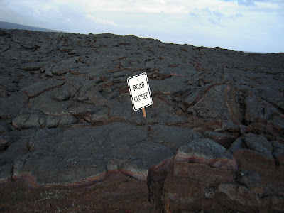
"Road Closed." Well, obviously! The lava must have had a little sense of humor.

You can just barely see the yellow posts where there was a gate blocking off the road.

We walked around on the lava that flowed over the road for quite awhile. It's really surreal. There were giant mounds of lava with huge cracks. I think this is where there must have been trapped gas and when it escaped, it pushed the lava up into these formations.


The drive back out of the park.

Ah, what a day! The weather was not optimal for lava viewing, so we didn't get to see that, but there is still lava flowing out of the side of the volcano even today! It is so crazy to think that we were out walking and driving around an extremely active force of nature. If you are ever close to a volcano, go and see it! Definitely worth the time.

 Kilauea Caldera. Calderas are formed after a volcano erupts. The lava chamber empties enough during an eruption that the land above is no longer supported and it collapses. Kilauea's caldera is 1.9 miles by 3.1 miles.

 These are steam vents and can be seen all over the place. Water seeps down cracks in the earth. As the water heats up in the hot earth, it rises and condenses into steam.
 Craters also "litter" the landscape. Craters are formed when lava is forced out of its basin underground. The roof collapses and thus a crater is formed. Craters are not the main exit for lava.
 You could actually hike down into some of the craters. If we had more time and it wasn't raining and if I was in better shoes, I would have liked to take a few hikes, too. Even though hiking really isn't my thing!
 You can see old lava flows all over the place. Some of the much older flows have vegetation while the newer flows do not. Driving along, you really feel like you're on another planet. I think the scenes from Armageddon even popped into my head. You know, where they're on the asteroid...trying to blow it up...
 This drive is called the Chain of Craters Road. You can stop and look at craters and the occasional steam vent for the first part of the drive.


 We're driving down to the shore line where the volcano meets the ocean.


 In this picture, you can see the different lava flows. Where the vegetation is is an old lava flow. The lava surrounding the vegetation is a lava flow that could have been as recent as 1972. It's really neat and interesting to see what the flows did and did not destroy on its way to the ocean.

 This is the last part of our drive down to the coast. Lava flow as recently as 2003 flowed across the highway and blocked access to the highway.
 If you click on the pictures, hopefully they will enlarge and you can get a better view. These pictures were behind glass at the station near the end of the road. The area inside of the red line is a shelf that collapsed in 2005. Forty-four acres of land disappeared into the ocean within four hours.
 When the shelf collapsed, a lava fire hose spewed out of the side of the cliff.
 The road is closed about a half mile away from where lava flowed over the road, so to get there, you have to hike. We're walking on the road and were tickled to see a little grove of palm trees amid all of the lava rock!
 Still walking...
 Whew! Made it. The lava over the road made me think of Ghostbusters and the giant marshmallow/Michelin Man!
 Funny how it just stopped in some places and kept going in others.

 "Road Closed." Well, obviously! The lava must have had a little sense of humor.
 You can just barely see the yellow posts where there was a gate blocking off the road.
 We walked around on the lava that flowed over the road for quite awhile. It's really surreal. There were giant mounds of lava with huge cracks. I think this is where there must have been trapped gas and when it escaped, it pushed the lava up into these formations.
 The drive back out of the park.
 Ah, what a day! The weather was not optimal for lava viewing, so we didn't get to see that, but there is still lava flowing out of the side of the volcano even today! It is so crazy to think that we were out walking and driving around an extremely active force of nature. If you are ever close to a volcano, go and see it! Definitely worth the time.


No comments:
Post a Comment